Maine
For a state that is largely rugged coastline and inland wilderness, Maine has a long history. The first English settlement was in 1607, the same year as Jamestown in Virginia. Lead by George Popham about 120 colonists arrived at the mouth of the Sagadahoc River (now the Kennebec River) and settled about 16 km (10 miles) south of modern day Bath, Maine. They began construction of Fort St. George and sent an expedition to contact the local Abenaki Indians. The Indians proved unwilling to help the settlers and with liitle food for the approaching winter about half the settlers returned to Britain. The remainder suffered through the harsh winter, but they did manage to build a ship, which they named Virginia. In 1608 the remaining settlers returned to Britain aboard the Virginia and a supply ship, so the Popham Colony did not count as a permanent settlement. Other settlements were established in the 1620s but the harsh climate and Indian attacks wiped out many of them. There was never a Colony of Maine as Massachusetts bought up most of the land claims and it was not until 1820 that Maine separated from Massachusetts. Modern Maine is famous for its coastline, its fall foliage and as the setting of many scary Stephen King novels. Does it deserve the scary image? It’s true that Maine can feel dismal when storms sweep in, but in fine weather the coastal scenery is beautiful and we have always found the people very friendly.
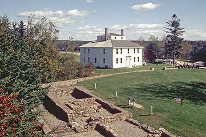
Fort House, Fort William Henry, Pemaquid
The threat to early settlers came not just from Indians but also from the French, who claimed much of the area. Three forts stood on this site to defend the Pemaquid settlement. Fort Charles was a wooden fort built in 1677 but destroyed in an attack in 1689. In 1692 a stone fort called Fort William Henry was built by the Massachusetts Bay Colony. In 1696 it too was destroyed by a combined French and Indian attack. In 1729 Fort Frederick was built on the ruins of Fort William Henry and it survived until it was decommissioned in 1759. Foundations remain and the western tower of Fort William Henry has been rebuilt. This picture shows Fort House, which was built as a farm house in the late 1700s. Click Tab 2 to see the reconstructed tower.
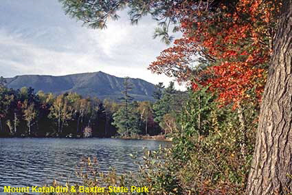
Mount Katahdin & Baxter State Park
The interior of Maine, particularly to the north, has some pretty wild terraine that can be very inhospitable in bad weather. The day this photograph was taken we had excellent weather, but the following few days were dismal. The way that this change of weather altered the look of the scenery was quite startling. The Appalachians end here at the summit of Mount Katahdin, which is 1,605 metres (5,268 feet) high. Set up in 1962, Baxter State Park aims to keep this area in its natural wild state.
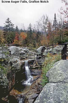
Screw Auger Falls, Grafton Notch
Finally a trip inland, close to the border with New Hampshire and only around 65 kilometres (40 miles) as the crow flies from the border with Québec Province. Screw Auger Falls are found in Grafton Notch State Park in the Mahoosuc Range of the northern Appalachian Mountains. Here the Bear River has cut a tortuous and intricately sculpted gorge through a banded formation of granite rocks.
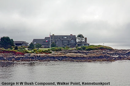
George H W Bush Compound, Walker Point, Kennebunkport
This is the summer home of George H W Bush, the 41st US President and father of the 43rd US President George W Bush. The estate was purchased by his maternal great-grandfather, David Davis Walker in the late 19th century. In 1902 he and Bush’s grandfather, George Herbert Walker, both built mansions on what was then known as Point Vesuvius. It has since been renamed Point Walker in honour of the Walker family. David D Walker died in 1918 and his mansion was demolished. In 1921 George H W Bush’s mother Dorothy Walker married Prescott Bush and George H Walker built a ‘bungalow’ on the Point as a wedding present. George H. Walker died in 1953 but he did not leave the estate to his eldest son, George Herbert Walker Jr. had to buy it. In 1977 George Herbert Walker Jr. died and the estate was purchased by George H W Bush as his summer home. Although George and Barbara Bush are both in their 90s they still spend 6 months of the year at the compound. Since this picture was taken a New England shingle-style house has been in the compound for the Bush’s second son Jeb.
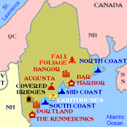
Click on Minimap to navigate
Home > US States > New England >
DLU180406
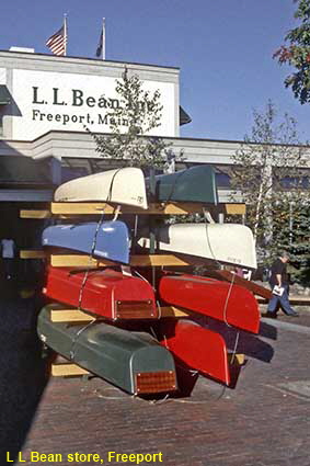
L L Bean store, Freeport
First settled around 1700, the village of Harraseeket was named after the river on which it stood. In 1789 it changed its name to Freeport. The town is now heaven for shopaholics, filled with boutiques, designer shops and outlet shops. The most famous shop in Freeport is the L L Bean store. Leon Leonwood Bean set up his first store in Freeport in 1912 selling shoes for hunting. Now a chain selling clothing and outdoor equipment, their Freeport store is open 24 hours a day every day of the year. There are no locks on the doors as the store is never closed. It is nice to know that if you need a canoe at 3am on Christmas day, you can buy one in Freeport.


We have more pages on Maine. Click below or on the Minimap:
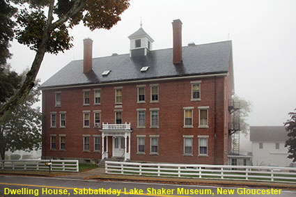
Dwelling House, Sabbathday Lake Shaker Museum, New Gloucester
We have visited Shaker Museums at Canterbury, NH, Hancock, MA and Old Chatham, NY but Sabbathday Lake is unique because it is home to the only remaining active Shaker Community in the world. At the time of writing there were just two Shakers left keeping alive the movement that once had 6,000 believers. The name Shaker came from their ecstatic form of worship with much trembling and shaking. Shakers are celibate so the survival of the movement has always depended on external recruits and in modern times few have been forthcoming. Sabbathday Lake Shaker Village was founded in 1783 on 730 hectares (1,800 acres) of land and within a year its Shaker community had grown to around 200 people. The objective of the community was to be self sufficient in food and the production of many of the artefacts that they used in their daily lives. There are 18 Shaker buildings at Sabbathday Lake, six of which are open to the public. It is open for guided tours Memorial Day to Columbus Day but is closed on Sundays when instead you can join the Shakers for their worship in the Meeting House. Click Tab 2 to see the Herb House, Boys Shop (now the Reception) & Spin House (now the Museum),
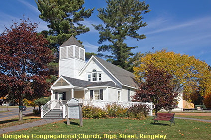
Rangeley Congregational Church, Rangeley
Rangeley sits on the shore of Rangeley Lake about 32 km (20 miles) east of the New Hampshire border as the crow flies. This is an area with many lakes and impressive fall foliage. Rangely Lake was originally called Aquassuc Lake but other local lakes have kept their Indian names: Cupsuptic, Kennebago, Mollychunkamunk, Mooselookmeguntic and Umbagog. In 1796 four men, including James Rangeley Sr., purchased over 12,000 hectares (30,000 acres) of land between the Kennebec River and the New Hampshire border. Travel beyond the navigable rivers was at that time very difficult and settlement did not start until 1810. James Rangeley, Jr. inherited the share of land from his father and he bought out the other three men. In 1825, Rangeley and his family made this remote place their home and about 12 years later it was named Rangeley. Primarily a farming community, it also did good business in lumber. The local farmers found places where large trout could be caught to supplement the food that they could grow and it was not long before word got back to the big cities. By the 1860s Rangeley was known as a fisherman’s paradise and soon it was popular with tourists. Rangeley peaked just before World War II but changing tourist tastes mean that the big resorts have now gone. It remains a popular tourist destination and the town now has a population of just over 1,000. It is a picture postcard tourist town but not everything is what it seems. Rangeley Congregational Church looks like a traditional New England Church but it was built in 1978.
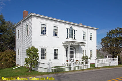
Ruggles House, Columbia Falls
Columbia Falls sits in the Pleasant River a short distance inland from Pleasant Bay. The eastern part of Maine is pretty quiet with most tourists going no further than Acadia National Park. The area may feel somewhat remote even now but in Colonial times it was very remote and sparsely populated. Columbia Falls was not settled until the time of the Revolutionary War and did not become an incorporated town until 1796. However, prosperity from lumber and shipbuilding has left the town with some fine examples of post revolutionary architecture. One person who became prosperous via the lumbar trade was Judge Thomas Ruggles who had this Federal-style house built between 1818 and 1820, He did not have much time to enjoy his house because he died in December 1820. The house passed to his descendants and remained in the family until granddaughter Lizzie Ruggles died in 1920. The house was saved by her cousin Mary Chandler who, just after World War II, restored it and opened it as a museum. The wing (or ell) at the rear of the house had to be demolished in 1938 because it had become unsafe. It was rebuilt in 2005 and in it are the remains of the remains of the original basement kitchen hearth which were uncovered during archaeological digs. The Ruggles House is open to the public mid June to Columbus Day in October. Click Tab 2 to see the remains of original kitchen hearth
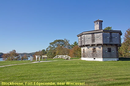
Blockhouse, Fort Edgecombe, near Wiscasset
On a peninsula known as Davis Island on the opposite side of the Sheepscot River from Wiscasset stands the historic blockhouse of Fort Edgecombe. In the early 19th century Britain was at war with Napoleonic France. The US remained neutral but both countries regarded the plundering of US ships as fair game. To punish Britain and France, the US passed the Embargo Act of 1807 which closed US ports to foreign ships and prohibited foreign trade by US ships. It was difficult to enforce and hence not a success. Britain and France found other markets for their goods and it was the people of the US who suffered most. The tensions with Britain and France persuaded the US Government that it needed to improve defences by building a series of forts. At the time Wiscasset was a major shipbuilding centre, and hence in need of the protection of a fort. The blockhouse and waterside battery at Fort Edgecombe were completed in 1809 The fort was used to enforce the Embargo Act but never came under attack. It was abandoned in 1818 but was reactivated for the duration of the Civil War. The Fort Edgecombe blockhouse is regarded as the best-preserved of its period in the USA. It is open only between Memorial Day and Labor Day so we could not go inside when we visited at the beginning of October.

© Mike Elsden 1981 - 2025
The contents of this page may not be reproduced in full or in part without permission