Capitol Reef National Park
Capitol Reef is the result of Mormon pioneers settling in a fold in the earth’s surface. The fold in question is the Waterpocket Fold which runs 160 kilometres (100 miles) from Thousand Lakes Mountain in the north to Lake Powell in the south. This very difficult terrain might well have remained a total wilderness but for one important resource - water. The Mormons settled here in 1880 close to the Fremont river and found that the soil was good for growing fruit and the land free from flooding. In the 20th century tourists used roads constructed by the settlers to come see the rugged beauty of the area. This led to Capitol Reef becoming an National Monument in 1937 and a National Park in 1971.
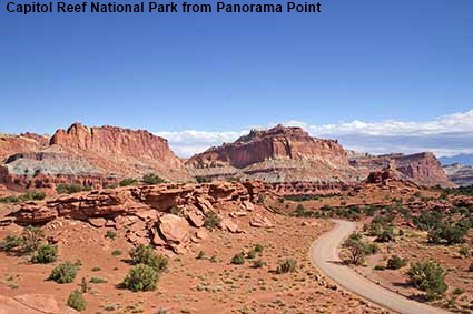
Capitol Reef National Park from Panorama Point
The approach to Fruita along the Route 24 from Torrey is a riot of red rock with stripes of grey. Panorama Point provides the best all round view of the scenery. From this picture it is difficult to believe that it was dull and raining when we arrived at the park for our 2005 visit. Fortunately the clouds cleared with amazing speed, although there were some lingering clouds still affecting the view in the opposite direction towards Chimney Rock. Click Tab 2 to see the view towards Chimney Rock.
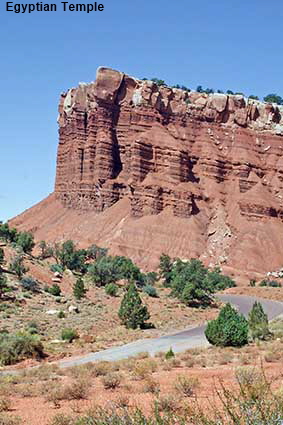
Egyptian Temple
From the Visitor Center a scenic drive runs south along the Waterpocket Fold. When we first visited in 1988 it was a gravel road, but by 2005 it had been surfaced (paved). The drive takes you up a valley past multicoloured cliffs. The most memorable is this cliff near the end of the drive which from this angle bears a striking similarity to an Egyptian Temple. The similarity is much less obvious from other angles, so don’t be surprised if you miss it on the way up, you will spot it when you come back. You can continue on from the end of the scenic drive on gravel roads, one of which takes you in to Capitol Gorge.
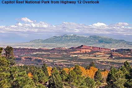
Capitol Reef National Park from Highway 12 Overlook
The red rocks of the Waterpocket Fold are clearly visible in this picture taken from outside the National Park. Behind them, the Henry Mountains loom over the fold, demonstrating that it is not height that makes Capitol Reef National Park inaccessible but the sheer ruggedness of the terrain.
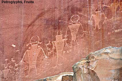
Petroglyphs, Fruita
The Fremont Indians were here long before the Mormons arrived, and they left a permanent record on the cliff face at Fruita. They were here between 700 and 1350 AD, living in pit houses and farming the land. These petroglyphs depicting human-like figures have weathered quite badly so the contrast of the picture has been enhanced to make them more visible.
DLU051027
Click on Minimap to navigate


To move forwards or backwards through the Utah trail click the arrows above, or select your next destination on the Minimap.

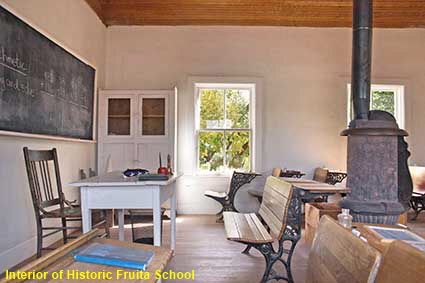
Interior of Historic Fruita School
The Mormon settlement in Capitol Reef was initially called Junction but in 1902 the name was changed to Fruita in recognition of its orchards. The area was known as "the Eden of Wayne County" but the terrain made it difficult to get the fruit to market. Attempts were made to improve market access by building a gravel road through Capitol Gorge, but even so Fruita could sustain only around 10 families. This single room schoolhouse was built in 1896 for the children of Fruita and was also used as a community centre. Today most of the land and buildings have be acquired by the National Park which has retained the orchards and historic buildings. Other buildings have been demolished. Click Tab 2 to see the school exterior.

© Mike Elsden 1981 - 2025
The contents of this page may not be reproduced in full or in part without permission
