Bryce Canyon National Park
Bryce Canyon is probably the best known of the National Parks in Utah. Along the pink canyon walls the limestone has been eroded to form blocks and pinnacles that resemble temples, spires and statues. The canyon is named after Ebenezer Bryce, a Mormon pioneer who settled in the valley below the canyon in 1870. Bryce drove a road into the canyon to provide access to timber supplies, so the canyon became known as Bryce’s Canon. Bryce moved on after 5 years but the name stayed behind. In the early 20th century people began to hear about the the canyon and it magnificent views, so in 1915 a road was built to improve access to the rim. In 1928 Bryce Canyon became a National Park.
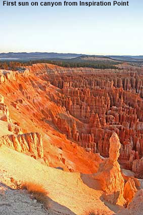
First sun on canyon from Inspiration Point
Sunrise and the early morning is the time when Bryce Canyon is at its most spectacular. At sunset the previous evening the viewpoints were heaving with people carrying cameras on tripods. The morning was freezing cold but we were still surprised to find that very few people were out to see the sunrise. We were chilled to the bone but at 7:30 when the sun rose it was the unforgettable view rather than the sun that instantly warmed us up. What you see here is what we saw, the colours in this picture have not been enhanced. The picture was taken in RAW mode using a Canon EOS300D and given only a small correction to adjust for slight over exposure of the brightly lit areas in the foreground.
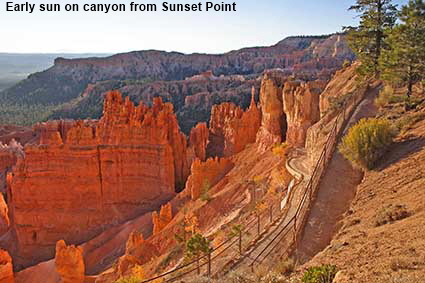
Early sun on canyon from Sunset Point
By 8:00 am a few photographers had appeared. At Sunset Point one told us that the best light on the canyon would be between 9 and 10 am, so we took a picture, went back to the lodge for breakfast and came back later to take another picture. You can decide for yourself when the light was best as Picture 1 was taken just after 8 am and Picture 2 just after 9 am. Is the 9 am light better or do the photographers not like going out early on a freezing cold morning?
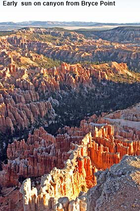
Early sun on canyon from Bryce Point
For our early morning views of Bryce Canyon we stuck to the viewpoints between Bryce Point and Sunrise Point that overlook the canyon amphitheatre and are close to the lodge. The Park road has many more viewpoints as it continues down to Rainbow Point but the road is nearly 30 kilometres (18 miles) long and has a low speed limit, so we would have missed most of the changing light. Bryce Point provides the best panorama of the amphitheatre formed by a curve in the northern end of the canyon. However we found the views at Inspiration and Sunset Points better for the sunrise as there you are much closer to the hoodoos. Even so, Bryce Point did not disappoint, as shown in this picture of hoodoos picked out by the rising sun while those behind remain in deep shade.
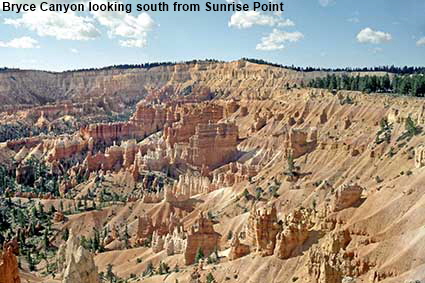
Bryce Canyon looking south from Sunrise Point
The views of Bryce Canyon at sunrise and sunset are legendary but during our first visit we were travelling from Cedar City to Torrey and so could only visit the National Park in the middle of the day. The hoodoos stand out well in the midday sun, but lack the colour that is picked out but early or late sun. In 2005 we revisited the canyon and stayed at the Lodge in the park so that we could see the canyon at both sunrise and sunset.
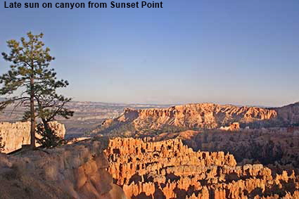
Late sun on canyon from Sunset Point
Although the light at sunset is good, the hoodoos are on the western side of the canyon and hence lose the evening sun fairly early. Nevertheless, photographers were out en masse, including one who hogged the precarious pinnacle on the left with a tree on it. We kept our cameras primed in case of a newsworthy picture of the demise of said individual. Eventually he moved on to allow others to capture the view.
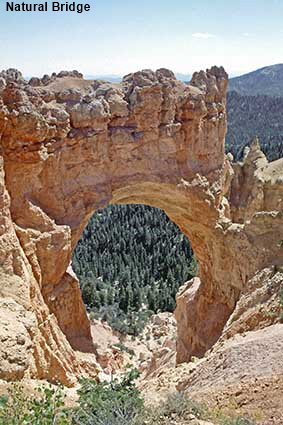
Natural Bridge
Although there are quite a few rock arches in Bryce Canyon, it is not particularly renowned for them. The best known is Natural Bridge which is conveniently close to the Park road. Apparently the name is technically incorrect as this is an arch (a result of weathering) rather than a bridge (where a river has cut through the rock). No doubt the National Park Service is bombarded by complaints from pedants!
Thor's hammer & Temple of Osiris from Navajo Trail
While the views from the many viewpoints are outstanding, to really appreciate the hoodoos you need to walk one of the trails from the canyon rim. It is only by walking among the hoodoos that you really understand why Ebenezer Bryce’s only recorded comment on the canyon was "It's a helluva place to lose a cow". In 1988 we took the Navajo Loop Trail from Sunset Point to see some of the fantastic shapes with mythical names. A word of warning, the canyon rim is at a height of around 2500 metres (8200 feet) so expect the walk back up to be hard if you are not used to the altitude.
DLU051025
Click on Minimap to navigate


To move forwards or backwards through the Utah trail click the arrows above, or select your next destination on the Minimap.


© Mike Elsden 1981 - 2025
The contents of this page may not be reproduced in full or in part without permission
