Wyoming
Although most of Wyoming became part of the USA under the 1803 Louisiana Purchase, it took a little while before it was explored as the 1803 - 1806 Lewis & Clark Expedition went through Montana rather than Wyoming. However in 1807 a former member of the Lewis & Clark Expedition called John Colter entered the area and discovered Yellowstone. His report of spectacular geothermal features was at the time dismissed as unbelievable. With little found in the way of gold and silver Wyoming became best known as a place to pass through on the route West, initially on the Oregon Trail and later by Railroad. Now it is known as the home of some of the best scenery in the USA, as well as those geothermal features that actually turned out to be real!
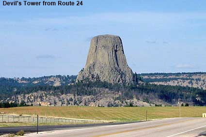
Devil's Tower from Route 24
This unusual rock formation in eastern Wyoming was already famous before ‘Close Encounters of the Third Kind’ catapulted it to superstardom. Rising 386 metres (1267 feet) above the surrounding countryside it is the remains of a 40 million year old volcanic neck that has been esposed by erosion. As the magma cooled it formed columns that give the Devil’s Tower its distinctive appearance. It is sacred to the local Indians who call it Bear Lodge.
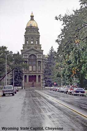
Wyoming State Capitol, Cheyenne
Like most US State Capitols, the Wyoming Capitol in Cheyenne is built in the ‘classical’ style, meaning that its design is based on the National Capitol in Washington DC. This was the first capitol building that we visited. Having become used to the high levels of security in Europe, we were amazed to find that we were allowed to wander freely around the building that is the centre of State democracy. We were even able to sit in the Speaker’s chair in the Senate Chamber. This was, of course, back in 1988, long before the attacks on September 11, 2001 brought high level security to public buildings across the USA. Click Tab 2 to see the Wyoming House of Representatives in the State Capitol.
Old Trail Town, Cody
Cody is named after Buffalo Bill, who surveyed the area in 1895. Here we find another re-creation of a frontier town, and not a bad one at that. The buildings were moved here from a wide area in the region and they date from 1879 to 1901. What makes this museum different is its huge collection of wagons. Also moved here in 1974 was the grave of trapper, hunter, army scout and marshall ‘Liver Eating’ Johnston who gained his name by killing Crow Indians and eating their livers. The movie ‘Jeremiah Johnson’ is loosely based on his life.
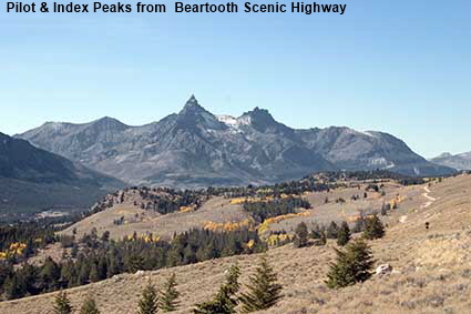
Pilot & Index Peaks from Clarks Fork Overlook, Beartooth Scenic Highway
Starting at Red Lodge in Montana the Beartooth Highway crosses into Wyoming shortly before it reaches its highest point, the 3337 metre (10,947 feet) high Beartooth Pass. Planned to provide a spectacular approach to Yellowstone National Park, construction of the highway commenced in September 1931 and the highway opened in June 1936. This view from the highway shows Pilot Peak which is 3,569 metres high (11,708 feet) and Index Peak at 3,448 metres (11,313 feet) high.
Click on Minimap to navigate
DLU161024
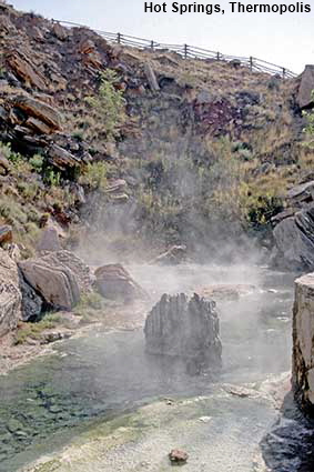
Hot Springs, Thermopolis
Geothermal features are not confined to Yellowstone National Park. In Thermopolis (from the Greek meaning “Hot City”), scalding water comes from the Big Spring, which is located in Hot Springs State Park. The water emerging from the spring is at a temperature of 57 degrees Centigrade (127 Fahrenheit) and is channelled to a Bath House where the water is maintained at 40 Centigrade (104 Fahrenheit). The Bath House is one of the best value attractions in the state - it is free with just a nominal charge for rental of towels and swimsuits.
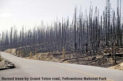
Burned trees, Yellowstone National Park
There is a separate page covering the scenery of Yellowstone, but this picture shows a hazard that is not confined to the National Park. When we first visited in 1988, Yellowstone was on fire. We had to drive through areas that were still smouldering, helicopters were continually buzzing overhead ferrying water, and our hotel in Cody was full of exhausted fire fighters. These large fires were a result of a now abandoned policy of snuffing out fires as soon as they started, which allowed flammable dead wood to accumulate. When we revisited in 2006 burned trees were still visible but the forest was regenerating. By our 2016 visit the areas that had burned could could still be identified by their smaller trees but most of the old burned tree trunks had fallen.


We have more pages on Wyoming. Click below or on the Minimap:


© Mike Elsden 1981 - 2025
The contents of this page may not be reproduced in full or in part without permission