The first European known to have set eyes on Paggank Island just off the tip of Manna-hata (Manhattan Island) was Italian explorer Giovanni da Verrazzano in 1524. Its name in the local Indian language meant ‘Isle of Nuts’ probably because it was covered with trees that bore nuts. The Dutch translated the name to Noten Eylant and In 1633 they established a military base there. After Britain conquered New Netherland in 1664 the island was reserved for ‘the benefit and accommodation of his Majestie’s Governors’, and it became known as Governors Island. Early in the Revolutionary War the Continental Army managed to fortify the island while the British Army and Navy were deployed in Boston. The British reoccupied the island in August 1776 and then took the city which they occupied for the rest of the war. In 1794, Fort Jay was erected atop the remains of the earthworks remaining from the Revolutionary War. Two two waterfront batteries were added, Castle Williams and South Battery. Thus began an era of continuous military use that continued until 1966. When the army moved out, the island became a base for the US Coast Guard.until the base closed in 1996. In 2001 nine hectares (22 acres) of the island were designated a National Monument and in 2002 the whole island was sold the people of New York for a nominal sum. Although some parts remain closed, the island is open to the public from May 1 to October 31 each year.
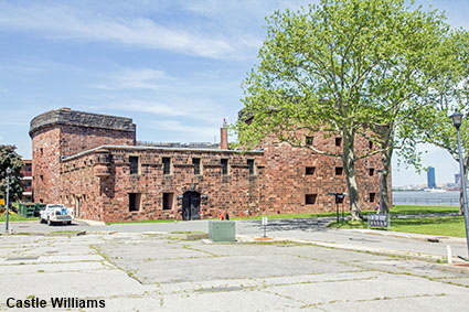
Castle Williams
This sturdy red sandstone building may look like a castle, but it was actually a high-rise gun battery. With cannon on three levels, the battery could cover an arc of 320 degrees. It was built between 1807 and 1811 to a design by Chief Engineer of the US Army Corps of Engineers, Lt. Col. Jonathan Williams. By the 1830s Castle Williams was obsolete so it was converted into barracks. During the Civil War it was used as a prison. In 1901 the US Army wanted to demolish Castle Williams but were overruled by Secretary of War Elihu Root. Instead, Castle Williams once again became a prison and it continued as such until 1965 when the US Army was preparing to move out. When the US Coast Guard took over the island they also wanted to demolish it but instead it was put to use as a community centre. The community centre moved out in 1970 and the building was then used for storage but by the time the US Coast Guard left the island it was in a sadly neglected state. The National Park Service renovated the building and opened it to the public in 2011.
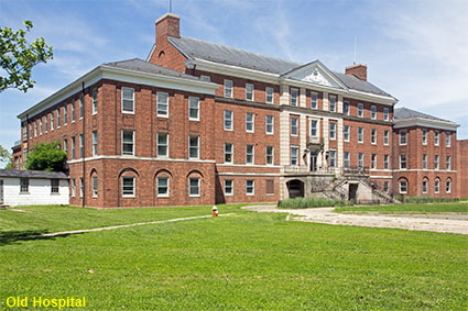
Old Hospital
When Governors Island was was a military outpost, the hospital was in Fort Jay. Elevation to an Army Headquarters meant that a much larger hospital was required. The Old Hospital is one of several historic buildings still in need of a new use.
DLU180625
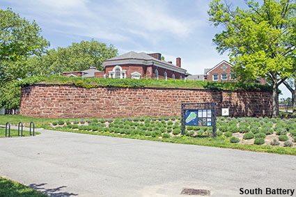
South Battery
South Battery seems to have been built in the wrong palce because it is on the eastern side of the island. The reason for this is that these sandstone fortifications were built in 1812, nearly a hundred years before the island was enlarged. When the South battery was built this was the south coast of the island. Click Tab 2 to see a view of the battery from the inland side.
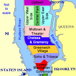
Click on Minimap to navigate
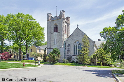
St Cornelius Chapel
A small wooden chapel called the Chapel of St. Cornelius the Centurion was built on Governors Island in 1846 primarily as a result of the efforts of army chaplain, the Rev. John McVickar. In 1866 the US War Department decided to cease stationing army chaplains on Governors Island. Trinity Church on Wall Street offered to take the chapel under its wing and provide a chaplain. This was agreed and in 1868 St. Cornelius became a part of Trinity Parish. In 1906 the Parish replaced the original wooden church with a new chapel designed by Charles C. Haight. In 1980 the US Government leased the chapel then in 1986 Trinity Church donated the church to the US Government on the understanding that it would revert to the parish if the government ceased to own the island. The US Government handed the church back in 1996 when the US Coast Guard left the island and the parish is now restoring it.
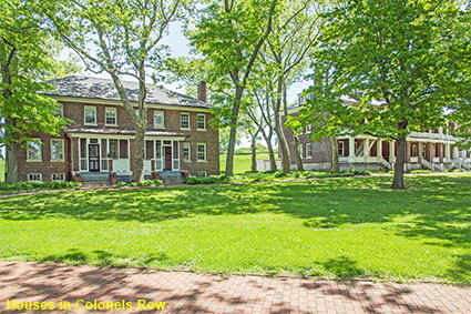
Houses in Colonels Row
By the 1870s Governors Island had grown from military outpost to US Army Headquarters. This meant that there were several senior officers based on the island. Six new brick houses were built for Generals, and they are now known as Colonels Row. The houses are now used from time to time for events such as art exhibitions.


To move forwards or backwards through the Manhattan trail click the arrows above, or select your next destination on the Minimap.
Governors Island
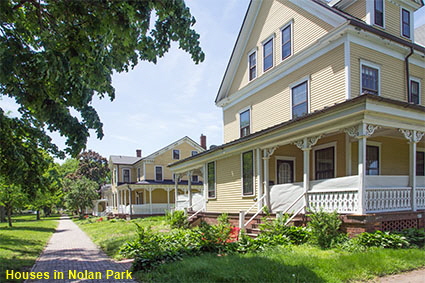
Houses in Nolan Park
On the east side of the island there are 15 houses for officers and their families Clustered around a tree-lined green, they were built between 1845 and 1902. In summer arts and cultural organizations now use these historic buildings to house exhibitions, shops, and activity spaces.
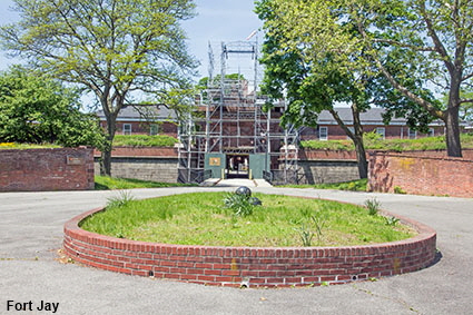
Fort Jay
When the British left Governors Island in 1783 the US did not move in to the abandoned earthen fort.. In the 1790s tensions with Britain began to rise so in 1794 work began to refurbish the fort, adding barracks and two new brick lined batteries. The new fort was named Fort Jay after John Jay, one of the Founding Fathers of the USA and at that time the Secretary of Foreign Affairs. The fort was never fully completed because Jay negotiated a 10-year treaty with the British which reduced tensions. After the Jay Treaty expired tensions rose once again, prompting the US to upgrade its coastal defences. A new fort was built on the site of Fort Jay, which was named Fort Columbus. Designed to hold 100 cannon, the new fort was completed in 1808. It did not see any action during the War of 1812 with Britain. After the war the fort fell into disrepair and major renovations were undertaken in 1830 giving the fort its modern day appearance. Other renovations took place in the 1860s and 1890s. The fort reverted to its original name of Fort Jay in 1904. When we visited Governors Island, Fort Jay was covered in scaffolding and firmly locked shut but it is normally open as part of Governors Island National Monument. Click Tab 2 to see a picture of the nearby Building 25 which was part of the original ordnance complex attached to the fort in 1811.
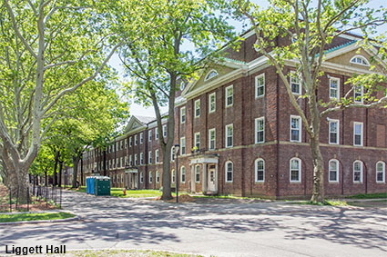
Liggett Hall
The most impressive barracks building on Governors Island is Liggett Hall. This long building runs almost from one side of the island to the other and was large enough to house an entire regiment. Designed by architects McKim Mead and White, it was completed in 1929. As part of the renovation of the island, an open air food court called Liggett Terrace has been built on the other side of the hall.

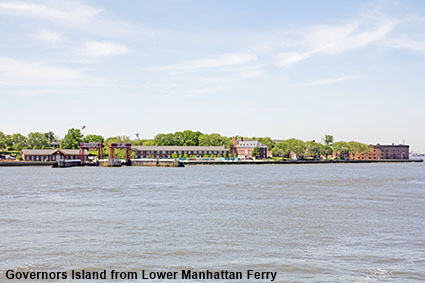
Governors Island from Lower Manhattan Ferry
Governors Island is a very short ferry ride from Manhattan as it is only 0.8 km (half a mile) from the tip of Lower Manhattan to the island. The distance from Brooklyn is even less, half to be precise, and there is a smaller ferry to bring visitors in from Brooklyn. In the early 20th century the island was increased in size by dumping spoil from the excavation of the subway line under Lexington Avenue on the southern side of the island. By 1912 Governors Island had increased in size from 41 hectares (103 acres) to 70 hectares (172 acres). The departure of the US Coast Guard in 1996 triggered a debate about the future use of Governors Island. The creation of Governors Island National Monument ruled out some of the some ideas such as converting Castle Williams into a theatre based on Shakespeare’s Globe. In April 2010, Mayor Bloomberg and Governor Paterson agreed a plan for the future of Governors Island and they set up a Trust responsible for implementing it. The plan included improved amenities and landscaping in the historic areas, new parks and a promenade around the island. The plans will take many years to complete, but already Governors Island is a popular place to go to escape the bustle of the city. Click Tab 2 to see the ferry terminal on the island at Soissons Landing and the view back to Lower Manhattan.
© Mike Elsden 1981 - 2025
The contents of this page may not be reproduced in full or in part without permission