The Sierra Nevada is a mountain range that starts just north of Lake Tahoe on the Nevada border and runs south as far as the Tehachapi Pass, about 110 kilometres (70 miles) north of Los Angeles. At 4,421 metres (14,505 feet) high Mount Whitney is not just the highest in the range, it is the highest in the lower 48 US states. On their eastern side, the Sierra Nevada drop away steeply to desert that lies in their rain shadow. In the south is Death Valley, one of the hottest and driest places in the USA. North of Death Valley is an area that is dry yet dotted with lakes fed by water from the Sierra Nevada. Some of these lakes are now dry courtesy of LA’s insatiable demand for water, while others flourish. It is an area the we, in common with many other tourists, failed to fully appreciate until in 2009 we spent some time exploring it rather than just passing through.
Eastern Sierra
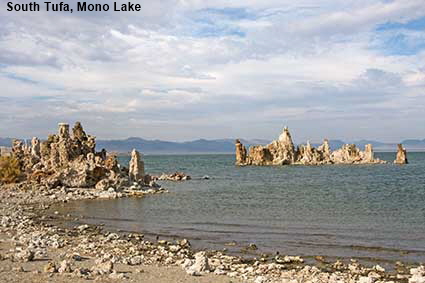
South Tufa, Mono Lake
At the eastern end of the road over the Tioga Pass you arrive in the town of Lee Vining with its views across Mono Lake. This is an ancient saline lake that nearly fell victim to the thirst of Los Angeles. In 1941 water from Mono Lake’s tributary streams began to be diverted in to an aqueduct conveying water to LA. The level of the lake fell, exposing columns of Tufa that had been formed by minerals dissolved in the water. By 1982 the lake had fallen nearly 14 metres (45 feet), leaving 7,500 hectares (18,500 acres) of the bed dry. An order to control water extraction was issued in 1994 and since then the level has been rising. The plan is to stabilise the level at about 8 metres (26 feet) below the 1941 level .Click Tab 2 to see a view of Mono Lake taken from the Lee Vining Visitor Center.
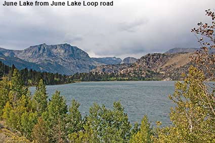
June Lake from June Lake Loop road
While the country around Mono Lake is very dry, only a little higher up the slopes of the Sierra Nevada the climate changes. June Lake is just 22 kilometres (14 miles) from Lee Vining but the scenery is totally different. It is one of a series of lakes along a loop road that runs through a valley with a subalpine climate surrounded by high mountains. Although it is a little fanciful, the valley has been dubbed the ‘Switzerland of California’. The lakes are very popular for trout fishing.
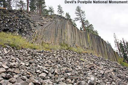
Devil's Postpile National Monument
Probably the best example in the world of columnar basalt can be found at the Giant’s Causeway in Northern Ireland, but California has some good basalt columns hidden away to the west of Mammoth Lakes. At the Devil’s Postpile National Monument columns up to 18 metres (60 feet) high form a cliff face. The columns are a result of the rapid cooling of a lava flow. As the flow cooled the basalt shrank causing vertical cracks to form through the rock. The classic basalt column has six sides, but the columns can have as few as three or as many as twelve sides. Here, the columns have been revealed by erosion and the rocks in the foreground are the broken remains of columns that have fallen off the cliff face.
Click on Minimap to navigate
Home > US States > The West > California >
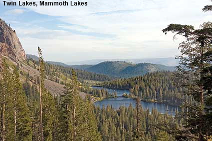
Twin Lakes, Mammoth Lakes
Mammoth lakes is a ski town 46 kilometres (29 miles) south of Lee Vining. The town gained its name from Mammoth Mountain, that overlooks the town, and a cluster of lakes just outside town. This picture suggests that Mammoth Lakes is a tranquil, subalpine area but in reality it has a hidden secret. This is part of the Long Valley Caldera, one of the largest volcanic calderas on the planet. It is far from inactive; earthquakes are common, the centre of the culdera is being continually uplifted and there are hot springs and fumaroles. At Horseshoe Lake high concentrations of carbon dioxide gas are being released from the ground and this has killed all of the trees along one section of the shore. Click Tab 2 to see the Gassy area at Horseshoe Lake.
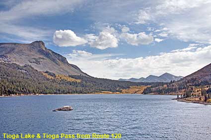
Tioga Lake & Tioga Pass from Route 120
Probably the best known scenery in the Sierra Nevada is at Yosemite National Park, and the road through it the Tioga Pass provides some great views. At the top of the 3,030 metre (9,941 foot) high Tioga Pass you leave the National Park and begin your descent down the eastern slope of the Sierra Nevada passing several mountain lakes. Tioga Lake is the first lake that you encounter during your descent, at a height of 2,940 metres (9,646 feet). This picture shows the view across the lake to the Tioga Pass and Yosemite National Park.
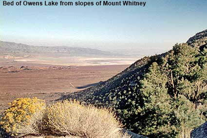
Bed of Owens Lake from slopes of Mount Whitney
This is the lake that Los Angeles drank dry. From the town of Lone Pine, you can drive up the Sierra Nevada towards Mount Whitney. As you go up, the desert scenery is replaced by plentiful vegetation. The rain that sustains this vegetation creates rivers that flow down into the desert below and they fed Owens Lake, a body of water large enough to once have a steamer service. From 1913 onwards, the City of Los Angeles diverted the rivers feeding the lake into the Los Angeles Aqueduct. With its water supply cut off the lake began to shrink and in 1924 the it dried up completely. The white salt flat visible in the distance is now all that is left of Owens Lake.


To move forwards or backwards through the California trail click the arrows above, or select your next destination on the Minimap.
DLU100526


© Mike Elsden 1981 - 2025
The contents of this page may not be reproduced in full or in part without permission