Colorado
To find history in the USA, most people head for the east coast to see relics from the early days of the British Colonies. However, Colorado has relics that are just as compelling and some are much older. In terms of US history Colorado is a mere youngster, with the eastern part becoming US territory under the 1803 Louisiana Purchase. 1858 saw the start of the Pike’s Peak Gold Rush which lasted until 1861, the first of several gold rushes in the area. The Colorado Territory was created in 1861 and in 1876 Colorado became a state. If you haven’t visited you will had heard of Colorado as a skiing destination, yet parts of the state are very flat. Indeed, Colorado has a three way split personality, with great high plains to the east, the jagged peaks of the Rockies in the middle and arid canyons to the west.
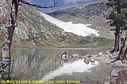
St Mary's Lake & Glacier, near Idaho Springs
Although it is called a glacier, St Mary’s Glacier is really a 4 hectare (10 acre) permanent snowfield. The difference? A glacier ice flows downhill, but a snowfield stays put. At an elevation of 3,500 metres (11,500 feet) St Mary’s Glacier has been created by snow blown off of the high mountains that make up the Continental Divide. Further proof that it is not a glacier can be found in St Mary’s Lake which collects meltwater from the snowfield. The lake is crystal clear, unlike glacier-fed lakes that have a characteristic turquoise colour. The ‘glacier’ offers year-round skiing, while the area around the lake is popular for hiking and camping.
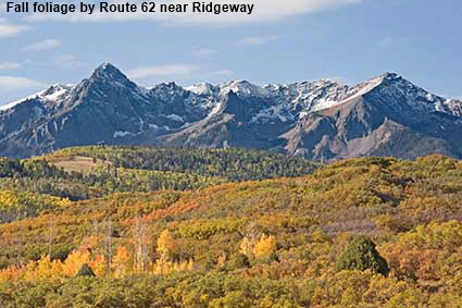
Fall foliage by Route 62 near Ridgeway
Think of fall foliage and New England comes to the fore, but the Colorado Rockies can also offer plenty of colour in autumn. While New England has a wide variety of trees giving a wide spectrum of colours, in Colorado the predominant colours are the yellows and oranges of the Aspen tree.
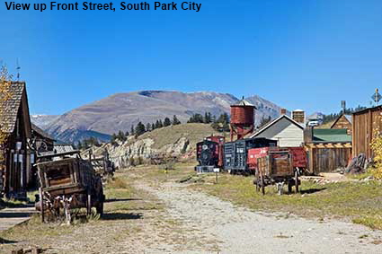
View up Front Street, South Park City
South Park is a high basin of grassland, surrounded by the Rocky Mountains. In 1859 gold was found in the west of the basin, attracting many prospectors into the area. The largest town is Fairplay and here can be found a re-creation of a town from the gold rush days. South Park City is an open-air museum of original buildings from the area, some of which are standing on their original sites. In case you are wondering, the South Park cartoon series on television is indeed linked to the area as co-creator Trey Parker grew up in a town not far from Fairplay. Click Tab 2 to see the interior of the J A Merriam Drug Store which contains authentic drugs and medicines from the 1880 store.
DLU081110
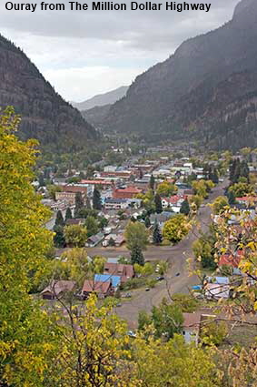
Ouray from The Million Dollar Highway
The city of Ouray nestles in a valley in the San Juan Mountains. Prospectors moved into the area in 1875 and Ouray was founded in 1876, named after the then chief of the Ute tribe of Indians. The town boomed and in 1877 the railroad arrived. Like many towns founded on mining, Ouray soon went into decline. The last passenger train ran in 1930, the railroad closed in 1953 and Ouray seemed destined to become a semi-ghost town full of old and neglected buildings. Unlike towns such as Aspen and Telluride, it was not the development of skiing that came to the rescue. Ouray re-invented itself as a four wheel drive destination in summer and an ice climbing centre in winter. The entire town is now registered as a National Historic District. The road running south from Ouray climbs up over the Red Mountain Pass. It is known as the Million Dollar Highway allegedly because of the high cost of construction in such difficult terrain. Click Tab 2 to see the City Hall & Walsh Library which was built in 1899, damaged by fire in 1950 and restored in 1988.
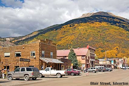
Blair Street, Silverton
Founded in 1874, Silverton had over thirty mills serving nearby gold and silver mines. The town stands at an elevation of 2,840 metres (9,318 feet) and the mines were even higher up in the mountains. Over time the mines became worked out, with the last big one closing in the 1990s. For most mining towns ghost town status would have beckoned, but Silverton had one big advantage, its spectacular location in a valley surrounded by the San Juan Mountains. Tourists keep the town alive, arriving either by road or on the Durango & Silverton Narrow Gauge Railroad. Silverton retains the atmosphere of an old mining town, with unsurfaced (unpaved) streets and old western style buildings, but behind virtually every facade you will find a tourist shop!
Click on Minimap to navigate
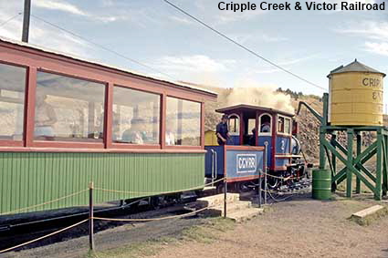
Cripple Creek & Victor Railroad
The 1891 Gold Rush resulted in three railroads rushing to get to Cripple Creek. The Colorado Springs and Cripple Creek District Railway was a standard gauge line that opened at the end of 19th century but come 1920 it had gone bankrupt and been dismantled. The line ran to Cripple Creek via Victor, one of the few places in Colorado where gold mining still takes place. In 1967 a 61 centimetre (24 inch) gauge tourist line opened on the old track bed between Cripple Creek and Victor. The 45 minute steam hauled journey takes you through the tailing piles and abandoned mine sites from the 1891 rush. In this picture Engine No.2, a 1936 Henschel 0-4-0 built in Germany, is taking on water at Cripple Creek.
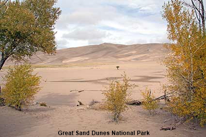
Great Sand Dunes National Park
The San Luis Valley is a large alpine valley surrounded by mountains. The Rio Grande has its source in the San Juan Mountains to the west and it flows through the valley to New Mexico. The valley was once the site of a large but shallow lake which dried out leaving behind deposits of sand. The prevailing westerly winds pick up the sand, and deposit it in front of the Sangre de Cristo Range on the eastern side of the valley, creating the tallest sand dunes in the USA. Great Sand Dunes National Park was created in 2000 to protect the dunes.


We have more pages on Colorado. Click below or on the Minimap:

© Mike Elsden 1981 - 2025
The contents of this page may not be reproduced in full or in part without permission